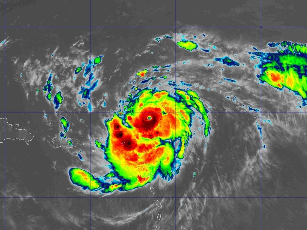
Hurricane Erin has strengthened to Category 4 as it moves across the Caribbean. It could intensify further as it threatens islands with strong winds and heavy rain. (Photo: US NHC)
Hurricane Erin intensified to a Category 4 storm Saturday, with maximum sustained winds reaching 130 miles per hour (210 km/h), Reuters reported. The US National Hurricane Center (NHC) has issued warnings as Erin moves through the Caribbean.
Currently moving approx. 170 miles northeast of Anguilla, the storm is tracking west-northwest at 20 miles per hour (31 km/h), with experts predicting that it may strengthen further as it continues its path across the Atlantic.
Though Erin’s has been quickly intensifying, it is not forecast to directly hit any island in the Caribbean. The storm, however, seems to already be having enormous impact, with its strong winds hitting nearby areas. Though weather deprtment has predicted that Erin will curve out of the mainland US, officials continued to follow the situation through into Saturday.
Erin, which initially developed as a Category 1 hurricane on Friday with winds travelling at an 85-mph speed, is expected to become even stronger. The storm is expected to intensify to Category 4 by Sunday night, with a swift rise in wind speed during the next 24 to 48 hours, a CNN report Friday stated. Such intensification is happening with increasing frequency through the warming of oceanic waters, a fallout of climate change.
“The stage is set for Erin to keep on rapidly intensifying,” CNN quoted NHC meteorologist Daniel Brown as saying. “The very warm waters in the western Atlantic provide plenty of fuel for this storm to grow stronger.”
Erin’s trajectory has it moving just north of the Leeward Islands, the Virgin Islands and Puerto Rico, where tropical storm watches are in place. The US NHC has cautioned that these have the potential to be upgraded to warnings as the storm approaches. While direct landfall appears unlikely, gusty conditions, heavy rain, and hazardous rip currents have become an increasing concern for the area.
It can rain as much as four inches in some of the islands, with some areas receiving as much as six inches of rain, according to the report. Flash flooding and mudslides are possible in vlnerable areas because of the heavy rain.
Although it’s too early to say whether Bermuda will be hit, the changing direction of the storm can push it more into the island’s direction, the report added. And even if Erin remains offshore, rough surf and dangerous rip currents next week can hit the US East Coast.
The Atlantic hurricane season has been forecast to be active, and additional storms could develop later in August and well into September. The hurricane center is already monitoring another potentially troublesome formation in the Gulf of Mexico.
Eid-ul-Fitr will be celebrated across India on March 21 after the Shawwal moon was not…
Rising tensions between Donald Trump and Benjamin Netanyahu signal a potential rift as US and…
Huge blow for Rajasthan Royals! England all-rounder Sam Curran is set to miss IPL 2026…