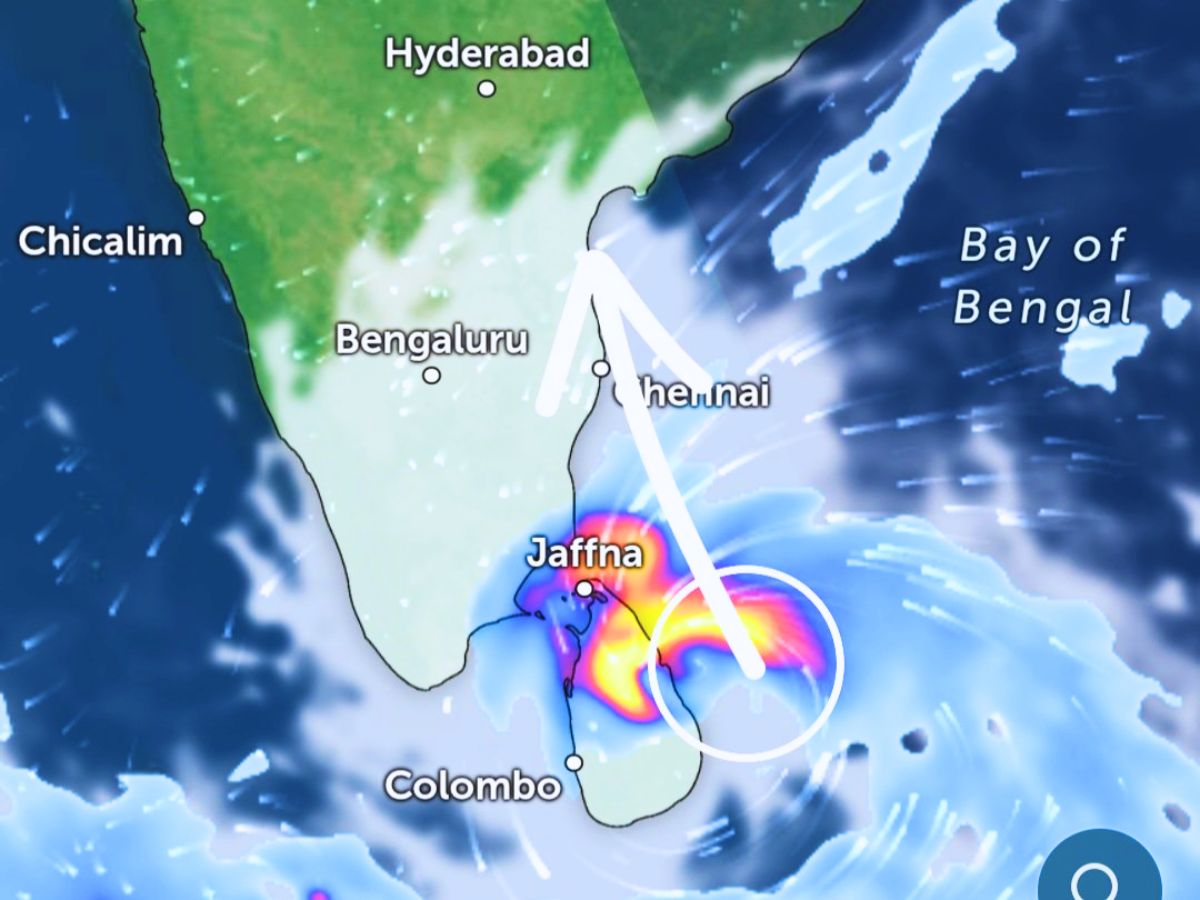
IMD said the deep depression lay centered near lat 6.3°N and long 82.4°E, about 150 km east of Hambantota in Sri Lanka. (Photo: X/@eastcoastrains)
A new storm is brewing over the Bay of Bengal just days after Cyclone Senyar emerged off the Strait of Malacca. The India Meteorological Department said a weather system over the southwest Bay of Bengal has intensified into a deep depression and is likely to further intensify into a cyclonic storm within the next 12 hours. It will be branded as Cyclone Ditwah once the system intensifies.
The IMD said the deep depression lay centered near lat 6.3°N and long 82.4°E, about 150 km east of Hambantota in Sri Lanka and about 170 km south-southeast of Batticaloa at 5:30 am on Thursday.
Yellow and orange alerts have been issued by the IMD for several districts in Tamil Nadu, including Chennai, Nagapattinam, Thiruvallur, Thanjavur, Cuddalore and Villupuram for November 27, 28 and 29 in view of heavy to very heavy rainfall.
Alerts are also in place for Puducherry and coastal south Andhra Pradesh. The IMD also said the deep depression will continue to move north-northwestwards across the southwest Bay of Bengal and adjoining Sri Lanka, nearly parallel to the Sri Lanka coast, before emerging close to the Tamil Nadu–Puducherry shoreline by November 29.
The weather department has warned of widespread rainfall, rough sea conditions and strong winds touching 80 to 90 kmph, with even stronger gusts along coastal areas.
The forecasters said the system may remain hovering over the nearby waters for the next 24 to 48 hours before further concentration. The IMD has warned of heavy rain, urban flooding in low-lying areas, high waves, and dangerous sea conditions along the coasts of Tamil Nadu, Puducherry, and south Andhra Pradesh in the next two days. Fishermen have been advised to remain ashore and asked people to monitor the updates on the weather conditions closely as a pre-cyclone watch has been set up for coastal districts.
Even as the Cyclone Ditwah becomes the focus of weather monitoring, the Cyclone Senyar has started weakening considerably. The IMD said that Senyar – which formed in the Strait of Malacca in what experts described as a rare meteorological occurrence – is likely to weaken into a depression before fading further by Thursday evening. Though moving away from Indian territory, Senyar may continue to bring isolated heavy rainfall to the Andaman and Nicobar Islands.
The developing storm, if becoming a cyclonic system, shall be officially referred to as Cyclone Ditwah according to the naming roster approved by the World Meteorological Organisation and the UN ESCAP Panel on Tropical Cyclones. The name given by Yemen refers to the well-known Detwah Lagoon in Socotra.
Coastal States Urge Preparedness as Second Storm Approaches Ahead of a second cyclone shortly after Senyar, the Bay of Bengal is gearing up, and emergency response teams in Tamil Nadu and Andhra Pradesh have been placed on alert.
State administrations have asked residents to avoid unnecessary travel to the coast, while maintaining caution and closely following IMD advisories as weather conditions continue to intensify.
Sofia Babu Chacko is a journalist with over five years of experience covering Indian politics, crime, human rights, gender issues, and stories about marginalized communities. She believes that every voice matters, and journalism has a vital role to play in amplifying those voices. Sofia is committed to creating impact and shedding light on stories that truly matter. Beyond her work in the newsroom, she is also a music enthusiast who enjoys singing.
Vivo is likely to launch the X300 FE soon in India. The phone is expected…
A lawsuit in the United States accuses Google of failing to prevent dangerous interactions between…
The Superintendent of Police in Panipat has received the document, which instructs authorities to make…