


Iceland is well-known for its spectacular scenery, unspoilt environment, and stunning landscapes. The best way to explore Iceland and to enjoy the landscape and beauty of Iceland is on foot.
There are many lovely sites to visit on the island, and many of them can only be accessed by foot, which is why Iceland has so many hiking routes. Furthermore, the paths here vary in length and difficulty, so you will almost certainly discover one that meets your physical abilities and interests.
There are several hiking and trekking trails here to pick from, and the most difficult aspect is deciding which one to take. To help you decide which options to take I bring for all the travellers a list of some of the best hiking trails in Iceland in this guide.
Laugavegur, the most famous hike in Iceland

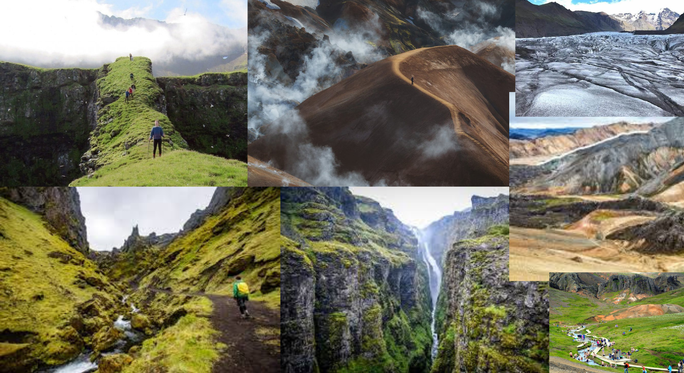
Laugavegur, commonly known as the Landmannalaugar Trek, is the most popular and one of the longest hiking paths in Iceland. The path connects Landmannalaugar and Thórsmörk in the Highlands, and if there’s one thing this trip is known for, it’s the range of scenery. You’ll drive through the geothermal area of Stórihver and the black volcanic ash desert of Mlifellssandur, as well as the famed and beautiful Brennisteinsalda mountain.
Before reaching Thórsmörk, the spectacular and lonely valley where the path terminates, you may also marvel at the Markarfljótsgljfur canyon. There are various mountain huts and camping spots along the path in Landmannalaugar, Hrafntinnusker, lftavatn, Hvanngil, Emstrur, and Thorsmörk, however camping is only permitted in a few designated areas.
This 34-mile one-way trek can take between 3 and 4 days to complete and has an elevation gain of 500 feet. This trail is rated as intermediate in difficulty, reaching a height of 4,265 feet. The optimum time to explore this trail is between the months of May and September. The weather and height rise at Hrafntinnusker and lftavatn might be an issue on this path.
Also read: Unlocking Adventure: The Thrills and Risks of Hitchhiking Explained
Mount Esja

The Esja or Esjan (the Esja) is unquestionably a notable landmark in Reykjavik’s skyline. It is a magnificent mountain range inside the city limits, and many inhabitants see it as a natural exercise place.
The path is so popular that you can even take a public bus to the mountain’s foothills. Esja is best hiked in good weather because visibility is critical in its steeper slopes. There are several paths one can take. They are all labelled with a scale of 1-3, allowing you to tailor the difficulty to your liking.
The path, which takes 2 to 3 hours up and 1 to 2 hours down, is considered simple by some hikers and moderate by others. The terrain can become rather steep at times throughout the trek, making it quite difficult.
There is, however, a café in the foothills on the parking lot’s right side. It’s a great place to stop before or after your trek. There are several pleasant locals working there, and one can find some tasty delicacies.
Mount Blahnjukur Hike

This 4.1-mile (6.6-kilometer) trip to the 3,051-foot (940-meter) high peak of Mount Blahnjukur (“Blue Peak”) can take up to one to two hours to accomplish and is classed as a moderate trail. Throughout the journey, you’ll be in awe by the surrounding lava flows and settled ash’s intense blacks and blues.
The mountain is located next to Brennisteinsalda mountain, and from its top, one can see five separate glaciers on a clear day. This is one of Iceland’s top walks for landscape photographers.
Skaftafell Trekking

Learning about the Skaftafell Glacier, one of the locations of the Vatnajökull National Park, while participating in the Skaftafell Glacier Trek is a definite adventure. It is one of Iceland’s top hiking paths for a reason. You’ll start at 10 a.m. and finish about 3:30 p.m., which means you’ll spend the next 5 hours hiking the gorgeous glacier with crampons on your feet.
The landscape is defined by massive ice formations of diverse forms. You’ll first come across “The Falling Glacier,” which is riddled with shafts, crevasses, and cracks. Then you’ll get a look at the bluish inside of the ice tunnels. Come on, you’ll be speechless after this journey.
Fimmvorduhals

The Fimmvöruháls hiking path, which goes from Thórsmörk to Skógar, is another popular hiking trail in Iceland. Many hikers combine it with Laugavegur, although it can also be done solo, making it an excellent option for individuals who prefer lengthy treks but are short on time.
The route runs between the glaciers Eyjafjallajökull and Mrdalsjökull and concludes in Skógafoss, one of Iceland’s most spectacular waterfalls. Throughout the trip, you’ll encounter several waterfalls, the Magni and Mói craters, and breathtaking landscapes with out-of-this-world geology.
The ascent to Fimmvöruháls is one of the more intriguing aspects of this trip. The green moss will eventually fade here, to be replaced by snow. With a distance of 15.5 miles, the trail may take up to 1-2 days to finish and is recognised as one of the most challenging trails in Iceland.
Its elevation reaches 4,230 feet, and the ascent to Fimmvöruháls can be difficult for hikers. The hike is best done between the months of May and September.
Also read: Discover Interlaken: Your Ultimate Guide to the Swiss Alps Gem
Kjolur

The route along Kjolur is sometimes referred to as “the Haunted Highway.” The name alludes to the difficulties Icelanders endured when riding their horses over the treacherous mountains on this rocky and frequently fragile track. The trail winds across the middle of Iceland, passing between glaciers and volcanoes.
Kjolur connects the North to the South and was formerly the shortest method to travel between the two. The journey is renowned to be difficult, especially owing to the merciless weather conditions, but if you are properly equipped and experienced, this infamous trek is a once-in-a-lifetime adventure.
The hike can take anything from 4 to 7 hours per day to 1 to 2 days to finish and is classed as moderately strenuous. The isolation of the route, as well as the weather conditions throughout the climb, can be difficult for hikers.
The Kjolur path, on the other hand, is not as strenuous as the 2-3 day one, but it does give a day out on the route capturing the highlights and hot spring swimming! It is a fantastic option for individuals who want to explore the path without being very skilled or equipped.
Glymur ‘The Trail to the Waterfall’

The trek to Glymur is breathtakingly beautiful. Waterfalls, clean streams, and gorgeous birch trees, as well as a lava cave and other unusual attractions, await you. Glymur waterfall is about an hour’s drive from the city centre, nestled in the valley of Hvalfjordur. The trek can become rather steep near the end, so be sure you have appropriate footwear. Strictness, on the other hand, tends to produce spectacular vistas, and this path is no exception.
Prepare to get out your camera and remember to spin around frequently.
The most preferred approach to hike the path is to start on the right side of the river, cross it on top, and return on the other side. This will allow you to view the spectacular water marvel from a variety of perspectives. Just remember to pack water shoes or you’ll have freezing feet.
This hike can take up to 3 to 4 hours and is graded as easy to moderate in difficulty. The trail is rather steep, and the river crossing demands balance, making it tough for hikers. There are no amenities associated with the waterfall trek, so make sure to use the restroom and eat something before embarking on it.
Thakgil

Thakgil is one of Iceland’s secret hiking treasures. It’s just about 30 minutes from Vik off the Ring Road, and the route there is really stunning. The route is gravel, although it is passable in the summer for most automobiles. Thakgil is nestled between glaciers and volcanic sand plains, yet it is also a rich oasis in its own right.
When you arrive, you will be spoiled for choice in terms of routes and sights, making Thakgil the ideal hiking location. It is especially useful for individuals who want to stay in one location yet hike out throughout the day. Thakgil is a fantastic campground that is ideal for families and environment lovers.
The campground serves as the starting point for the majority of the walks in the region. The hiking routes to Remundargil Canyon and the creek with the waterfall are two of the must-sees. The stream may be found by following the hydro plant that feeds the campground. The trek’s duration is determined on the hiker’s pace and can take up to 2 hours to finish.
It is considered as a simple trip with no major challenges; nevertheless, getting there in winter might be difficult. Every year, from June 1st to August 31st, the campsite is open.
Reykjadalur

This is the greatest trip in Iceland if you want an easy climb that combines gorgeous views with calming hot springs. This out-and-back path is located near Reykjavik, Iceland’s capital, in Hverageri. The path passes through the Reykjadalur Valley, one of Iceland’s most active and attractive geothermal sites.
There are many Icelandic hot springs here, but the most popular area to bathe is in the river. The swimming area is roughly 10 feet from the Hverageri parking lot and even has some privacy barriers so you may change into your bathing suit.
While the notion of relaxing in these hot springs in winter is appealing, hikers must be cautious since there is typically ice along the path. Furthermore, the Reykjadalur trail is great for viewing the Northern Lights, making it a must-hike if you visit Iceland between late August and mid-April.
With a distance of 4 miles and an elevation of 985 feet, this walk might take up to 2-3 hours to accomplish. The walk is classified Easy in terms of difficulty and may be visited all year. The main difficulty hikers may encounter on this walk is ice throughout the winter.
The Hornstrandir trek

This walk is really distant. There will be no people and especially no automobiles. The location is well-known for being inaccessible to motorised vehicles. As you go through the National Park, you will be immersed in nature and entirely isolated. As wonderful as it is, it also means you’ll need to consider things like bringing food for six days and tents.
As if that weren’t enough of a struggle, the location is only accessible by boat during the summer . Hiking is only permitted from late June to mid-August due to rigorous preservation laws. Most individuals spend up to 6 days, averaging 4–7 hours each day, to finish the 53-mile (86-kilometer) walk.
This trek’s difficulty varies from Moderate to Challenging. The hikers may face a few hurdles, including the trek’s remoteness, a lack of services, and the possibility of inclement weather.
Also read: All the Things You Need To Remember for Your Next Solo Trip
Viknaslodir Hiking Trails in the Eastfjords

The Viknaslodir region of East Iceland is known as “The Routes of the Inlets” because of its numerous hiking trails. It is advised that you spend five to ten days hiking here. The region is divided into North and South, however a five-day highlight tour is also available.
The path is approximately 93.2 miles (150 kilometres) long and is regarded as one of the greatest walks in Iceland. Expect towering mountains, breathtaking seaside views, wonderful beaches, lovely fjords, colourful mountains, green valleys, and turquoise blue waters.
It should be noted that trekking in this region should be tried only during the summer season, as the roads leading to Borgarfjordur Eystri (or the East of Iceland in general) may be closed owing to heavy snow in the winter.
So you wouldn’t even be able to get to the beginning of your journey, and the huts along the road aren’t open in the winter to keep you warm.
Borgarfjordur Eystri to Seydisfjordur Hike

A beautiful trek of 34.1 miles (55 kilometres) between the towns of Borgarfjordur Eystri and Seydisfjordur is available between the towns of Borgarfjordur Eystri and Seydisfjordur. The hike takes three to four days and takes you down the coast of Eastfjords via the village of Husavik.
It is mainly known for the breathtaking view of the North Atlantic Ocean as it passes between little farmsteads and steep mountains. With a distance of 34.1 miles (55 kilometres), the trail may be completed in three to four days. The journey is graded as tough.
Also read: Travelling Alone? Explore The Challenges Of Solo Travels