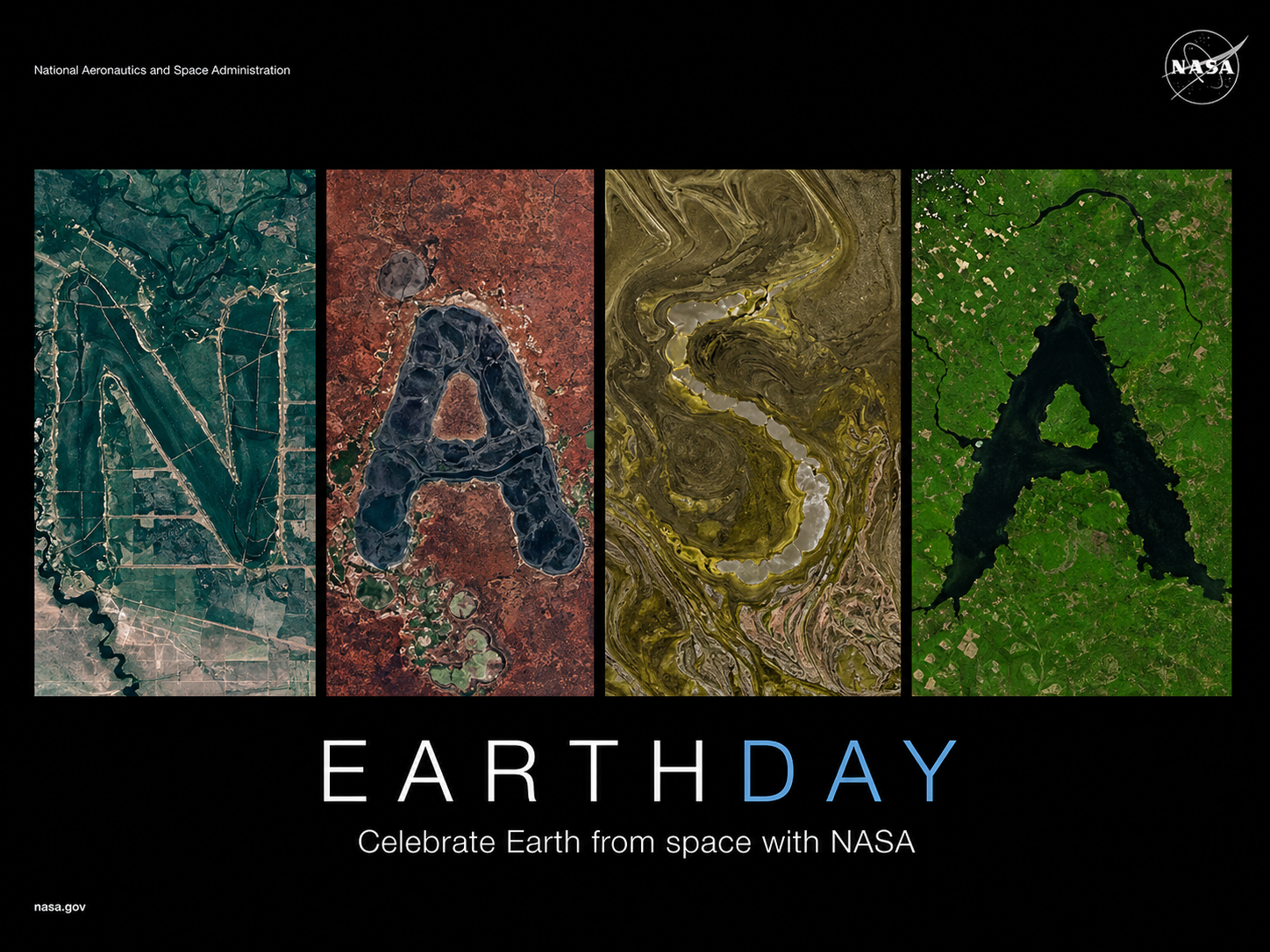
NASA has developed an innovative program that teaches Earth science to people through its new initiative called ‘Your Name in Landsat’. The tool launched on Earth Day 2026, which enables users to discover their names that appear in actual satellite images of Earth landscapes. NASA transforms scientific data that spans multiple decades into an enjoyable educational experience through its combination of advanced space technology and user-friendly interactive design.
What Is ‘Your Name in Landsat’?
The ‘Your Name in Landsat’ tool belongs to NASA’s ongoing Landsat project, which the organization developed together with the US Geological Survey (USGS).
The system uses more than 50 years of satellite images to detect natural landforms, which include rivers, mountains, coastlines, and deserts that display characteristics of alphabet letters.
The system enables users to enter any name, which the system then matches to satellite images that visually resemble each letter of the name. The result is a unique name created entirely from real features found on Earth’s surface.
How To Create Your Name Using NASA’s Tool
Creating your name through this initiative is simple and takes just a few steps:
- Visit the official ‘Your Name in Landsat’ webpage
- Enter your name using letters from A to Z
- The tool searches its database for matching landform images
- Each letter is assigned a satellite image resembling that shape
- The final result displays all locations with their corresponding coordinates
- Users can either download or share their customized Earth-based name image
The platform provides an Alphabet Image Gallery, which contains multiple satellite images that show each letter of the alphabet.
The Science Behind It
The Landsat program, which NASA and the United States Geological Survey operate, has been observing Earth’s surface since its launch in 1972. The satellites employ remote sensing technology to capture light reflections from Earth, which enables scientists to track environmental transformations that include deforestation, urban expansion, and glacier retreat.
The scientific research field uses high-resolution multispectral data, which now supports the development of an interactive naming experience to make scientific information more understandable to the general public.
Why The Landsat Mission Matters
The Landsat mission serves as the benchmark for Earth observation studies. The study helps researchers understand climate change while they use it to manage natural resources and monitor environmental conditions across different regions of the world. NASA uses visual data representations to attract more people to study Earth science through their work.
A Creative Earth Day 2026 Initiative
NASA will launch ‘Your Name in Landsat’ on Earth Day 2026 as one of its multiple projects to increase public awareness and interest in Earth science. The project shows Earth through its most beautiful and diverse landscapes, which also demonstrate how space technology creates new interactive experiences.
Harshita is a journalist and digital content writer specializing in breaking news, current affairs, travel, education, and trending stories. She is focused on delivering accurate, timely, and engaging content with a strong emphasis on clarity and audience relevance.